
Polar Scope Simulation calculates the position of Polaris relative to the north celestial pole from the current location and time, then displays it as an optical polar-scope reference. It assists mechanical polar alignment and sends no movement commands to ONSTEP.
From the Alignment section of Setup & Alignment, select Polar Scope Simulation.
Applicability
This function uses Polaris as its reference and is intended primarily for Northern Hemisphere observing. The mount must have an optical polar scope, or an equivalent structure, through which Polaris can be observed.
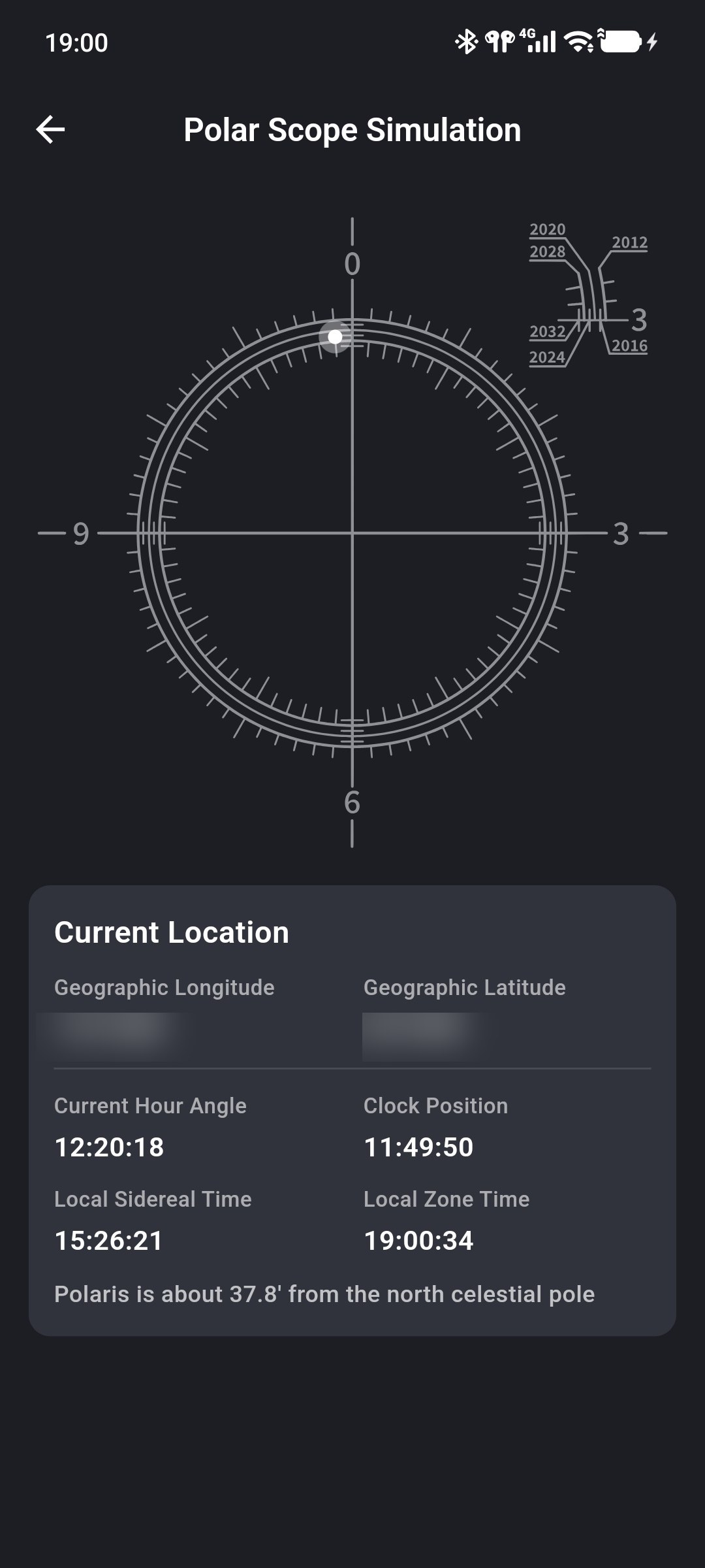
Read the Simulated Field
The circular diagram represents a polar-scope field:
- its center is the north celestial pole;
- the illuminated point is the reference position where Polaris should appear at the current time;
- the point's direction and distance from the center change over time.
The page recalculates automatically at intervals; no manual refresh is needed.
Verify Location and Time
The lower section displays the data used in the calculation:
- Geographic Longitude and Geographic Latitude: from the connected ONSTEP device;
- Current Hour Angle: the position of Polaris relative to the local meridian;
- Clock Position: the direction of Polaris in the simulated field expressed as a clock position;
- Local Sidereal Time: sidereal time at the observing location;
- Local Zone Time: the phone's current time;
- Polaris is about … from the north celestial pole: the angular distance from Polaris to the field center.
Before use, verify the ONSTEP coordinates under Time & Location and confirm that the phone's system time is accurate. Incorrect coordinates or phone time directly affect the simulated position.
Align with an Optical Polar Scope
- Set up the mount and mechanically point the polar axis approximately toward the north celestial pole.
- Open Polar Scope Simulation and verify its coordinates and time information.
- Locate Polaris through the physical polar scope.
- Compare it with the simulated field and use the base's azimuth and altitude adjusters to move Polaris to the corresponding clock direction and distance.
- Lock the base and recheck Polaris to ensure locking did not change the alignment.
Check the field orientation
Image orientation, reticle orientation, and installation angle vary between polar scopes. Before first use, consult the mount or polar-scope manual to determine how the real field corresponds to the App simulation. Do not adjust solely from left and right on the screen.
Difference from Smart Polar Alignment
Polar Scope Simulation provides only a Polaris position reference. It does not require Three-Star Alignment and does not measure the current polar error automatically.
Smart Polar Alignment calculates altitude and azimuth error from Three-Star Alignment and is suitable when no optical polar scope is available or when polar error needs further checking. Use either function according to the equipment and observing conditions.
Invalid Page Data
- If the coordinates are incorrect, return to Time & Location and synchronize the mount location.
- If the time is clearly incorrect, check the phone's system time, timezone, and automatic time settings.
- If the astronomy library fails to load, leave and reopen the page. Restart the App if the problem continues.